Something I've been up to in the background recently has been research into mapping imaginary spaces, and hopefully I'll have a few outcomes to share in the coming weeks before Christmas. I've always been fascinated by maps; not only are they beautiful to look at, but they can tell us so much about how we view our place in the world. Civilizations, both contemporary and ancient, reveal much in how they position or distort different areas of the world, from what they leave out - or what they add in that isn't there.
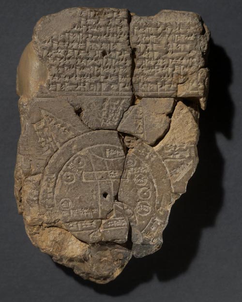
Translation was another mapping project I began almost exactly a year ago. It was borne out of a desire to reconcile one of the oldest known maps of the world - an ancient Babylonian clay tablet (see the photo below) - with modern day satellite imagery. The Babylonian artefact is sadly damaged, but its representation of the world as an eight pointed star - with the Earth as a disk surrounded by a 'bitter sea', and triangular outcroppings representing far off or mythical lands - was unlike anything I'd ever seen. And Babylon is firmly pressed into the centre of this map, unlike the Anglo-centric projections we use today. What would an updated version of this map look like?
I knew from the start I wanted this project to be collaborative - I didn't want this to just be my view of the world, but an effort that involved people from different countries and cultures. And its still ongoing, so frustratingly I can't reveal too much from the results just yet - but that also means there is the chance to get involved... send me an email if you're intrigued, of watch out for more specifics about Translation appearing on here soon.
If you're interested, there is more information about the map tablet on the British Museum website. I spent several days studying this artefact in person at the British Museum in November 2013 and would like to take this opportunity to thank all the staff in the Middle East department for their help, especially Dr Irving Finkle for his invaluable assistance in translating the text on the map and helping me to understand its cultural significance.

 RSS Feed
